Saturday, I'm doing another Willamette Valley Geology Workshop for the Oregon Master Naturalist Program, and yesterday Bob Lillie and I went over the schedule, outlines of presentations, and scouted out the Marys Peak Geology field trip we'll be doing to top the whole thing off. I've posted various bits of stops up Marys Peak in the past, but never really brought the whole thing together in one cohesive guide before, so I hope this is useful to people who are interested in exploring the area on their own.
Imagine Coffee is at 53rd and Philomath Boulevard (Route 20/34) between Corvallis and Philomath. I had never been in there before yesterday, but based on my visit, it's a nice relaxing space, with good coffee, tasty breakfast sandwiches, and a nice selection of pastries. I'm sure they wouldn't mind your business, but if you're in a rush, just zero your odometer as you go through the intersection with 53rd Street.
Why Marys Peak? I know my Oregon Central Coast Range geology pretty well, and there is no place that gives an as complete or well-exposed transect as the drive up Marys Peak. It shows a tale of ocean floor eruptions, building to Hawaiian-style subareal eruptions, with associated erosion and deposition of volcanoclastic sediments on the flanks of that(those) island(s). This was followed by subsidence, accretion to North America, and pretty much at the same time, burial under a voluminous Eocene sediment source in the form of an apparent river drainage coming out of the Idaho Batholith. I've seen speculation that the headwaters of this drainage lay in the lake environment that created the Green River Formation in the UT/WY/CO tri-state area, but I don't know whether that was ever confirmed. While the coarser deltaic facies of the Tyee Formation now lie to the south, in the Roseburg area, in the central coast range, this unit forms well-defined couplets of sandstone-silt/mudstone turbidites. Finally, about 30 million years ago, as the reactivated (after stepping back and reinitiating following the above-mentioned accretion) Cascadia subduction zone got going, a series of Oligocene intrusives invaded the Coast Range. The thousand-foot-thick Marys Peak Sill is an outstanding example of one of these, and its resistance to weathering and erosion make it a capstone protecting the softer underlying rocks, explaining why Marys Peak is the highest in the Coast Range.
Even if you aren't into geology, the drive to the top is replete with wonderful scenery and a parade of ecological change as you drive through ever higher elevations and frequent changes in aspect, leading to large variations in sun and moisture availability. The views from the summit area are to die for. And for geologists, the ability to walk from one side of a parking lot to the other, and see from pretty much directly over the subduction zone, under the ocean horizon to the west, the forearc ridge (where the peak stands), the forearc basin (the Willamette Valley), to the volcanic arc (the Cascades), is utterly mind blowing. You can, from one spot, see a cross section of one of the major features resulting from the plate tectonic activity of our planet.
0.0 Start (Intersection of 53rd and Philomath Blvd-Route 20/34)
0.4 View to north of hills on N side of Corvallis Fault- Siletz River Volcanics
3.7 Turn Left on Route 34, to SW, toward Alsea & Waldport
10 .0 Switchbacks up to Alsea Pass
11.1 (pull off on left; caution crossing opposite lane)
Stop 1: Steeply dipping beds of Tyee Formation turbidites.
12.7 Turn right onto Marys Peak Road
14.8 (Optional stop- not easy to get more than one or two vehicles off the road here, not recommended for larger groups) Hyalocalstite below (on the right, if you're facing upslope), crudely columnar jointed basalt sill above (left). In between, a few inches of Kings Valley Siltstone, the result of erosion and deposition of Siletz River Volcanics that erupted subareally. This is the lowest (stratigraphically) spot in which I've found it.
15.9 (Optional stop) Pullout on left. Across the road is a nice set of columnar joints that roll over along the outcrop, so you can see them both from the side and on end. They rest over some oddly and very heavily weathered sphereoids of (possibly) a pre-existing flow. I'm not certain how to interpret this contact, but I've been considering that it might be a stream channel that was filled by a later subaereal flow. I want to emphasize that that idea is highly speculative, but I haven't been able to come up with an explanation I like better.
16.4 Large parking area on left, pull out and regroup for walk to
Stop 2, Pillow Basalts (+lunch)
See further discussion here. Hand sledge for scale on lower left of outcrop.
18.2 Harlan Road to left (Optional side trip) Drive about a mile down a very rough, pot-holed gravel road to the outcrop just past where the power line crosses the road- there's room to get off the road on the downhill side at the lower end of this outcrop. This is the best exposure I know of of the Kings Valley Siltstone, though it's weathered pretty badly over the years.
See this for a detailed discussion of the unit. Another feature here are some ashy layers. It was suggested in the early 80s that these might be derived from the
Challis Volcanics (PDF), and with the clearer picture of the Coast Range block migration that emerged in the mid to late 80s, that seems to make even better sense.
Continue down the road another 1/2-3/4 mile (We didn't do this spur on our scouting trip yesterday, so I don't have good mileages), to where the road turns well into the hillside to contour into a significant drainage, Parker Creek. There a very obvious parking area, a fire ring and a number of large, beautiful cedars. I particularly like this spot due to the gorgeous riparian habitat, with ferns everywhere, and the gigantic trees. Geologically, though, we've gone downhill, but up section- the bedrock is Tyee Formation, which overlies the Siletz River Volcanics and its associated Kings Valley Siltstone member. So we can infer a significant fault somewhere between the previous stop and this one. Return to the main road, and turn left.
19.2 Pull out to left as far as possible, walk back to
Stop 3, Tyee Fm, Kings Valley Siltstone, fault and landslide
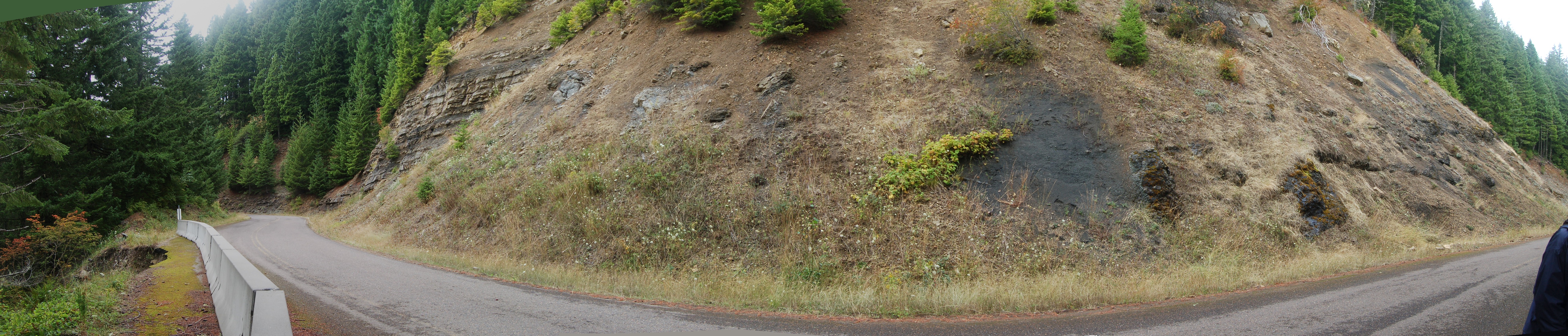
(
Click here for a selection of sizes at Flicker; right click on that image for a list of size choices. Alternatively, right click on the photo above and open image in a new window.) To the left, you can see the horizontally bedded Tyee Formation, with its well-defined sand-mud couplets. On the right, the poorly bedded and more chaotic Kings Valley Siltstone stands out mostly because it's so much darker- almost black- than the Tyee. Again, we can infer a fault between these two exposures. Another point of interest is that you can see the base of the Tyee above the Kings Valley on the right side (though it doesn't really show up in the above photo)- the only place I think I've ever seen the base of that unit. On the left-most side of the photo, you can see a temporary Jersey Barrier, and the edge of the road has collapsed. This has been repaired, and the barrier replaced with a hefty guardrail, but this failure was very likely due to the fault, which shattered the rock, and allowed easier access for water and air to weather the zone out more quickly and easily than elsewhere.

19.6 Parking area to right for
Stop 4, Parker Creek Falls, Marys Peak Sill (Gabbro) This is a terrbly tough, resistant rock that intruded into the base of the Tyee about 30 million years ago. It has acted as a protective capstone, about a thousand feet thick, over the softer, more weathering and erosion-prone rocks below it. That, in combination with uplift between the Corvallis and Kings Valley faults, explains why Marys Peak is nearly 1000 feet higher than the highest of the other Coast Range Peaks.

21.2 (Optional stop) Meadow Pullout on right. Due to elevation, with subsequent harsh winter weather- deep snow pack, powerful winds, bitter cold, and comparatively short growing seasons- along with parched, dry summers- this is the first place along the road where we see the mountain meadows that dominate the crests and south sides of the Coast Range's tallest peaks. Flower season runs from early May into July, with a long cast of characters that's constantly changing. Take a moment to consider how the stack of geology we've seen so far has created the environment that supports this botanical wonder, then walk east up the road and look for the rocks in the road cut. This type of rock is called hornfels, and it was created by contact metamorphism when the sill below cooked overlying Tyee sandstones and silts.
See Dana's post for more information being explained by me in video format.
22.3 Summit Parking area,
Stop 5: views of subduction zone, forearc ridge, forearc basin, and volcanic arc. I can't say enough about this spot. There must be other places in the world where you can basically see from the location of the subduction zone to the associated volcanic arc, but this is the one I know. And it blows my mind every time I get up there on a clear day.
Again, here's what Dana had to say about it. Below is a view to the west from near the summit parking area; the dim blue line is the horizon above the Pacific Ocean, and a bit of trigonometry suggests that the horizon is about 75 miles distant- very close to the location of the decollement fault where the Juan de Fuca plate begins its dive under North America!
One final optional side trip, if you want a bit more petrologic goodness. At the northeast corner of the parking area, a trail descends the mountain side after following the summit ridge a ways. Walk a few hundred yards/quarter mile or so down the trail, and
keep an eye out for cobbles of Marys Peak Sill weathered out onto the surface.
Enjoy your geotripping!


2 comments:
This is very cool ... I wish it weren't so far away!
It really is a blast. Living so close by, I have on occasion come to take it for granted. Then I went some years without visiting, and on trips lately, it's been much easier to keep in mind what a terrific and unique spot it really is.
Post a Comment